Dubai Metro Map
Looking for the easiest way to travel around Dubai? Fast, clean, and reasonably priced, the Dubai Metro Map makes it easy to navigate the city like a pro for both daily commuters and tourists.
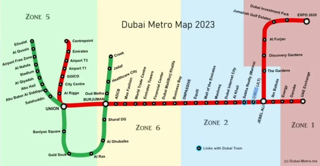
The information we have gathered about the Dubai metro station map, the zones, and the most recent information about stations that are open has been used to create this map. Please be aware that this map of the Dubai Metro is protected by copyright and should not be used without our prior consent.
What is the Dubai Metro map?
A comprehensive guide that displays all of Dubai’s metro lines, stations, and routes is the Metro Map. By utilizing the Red and Green Lines, it facilitates easy city navigation, connection discovery, and speedy destination arrival.
Regular updates to the map dubai metro
When the metro is expanded farther out, we will keep the metro map updated with new station names and any new stations that might open. Sometimes businesses buy the branding rights for a specific station, which results in changes to the station’s name. You can read about these changes in the news section.
Dubai Metro Map 2026
Some of the stations took some time to open. On the other hand, all of the stations on the green and red lines were fully operational as of March 1, 2014, and the Expo 2020 extension was fully operational in 2021. The current 18 green line stations and 35 red line stations will probably be expanded in the future.
Dubai Metro Map Zones and Ticket Prices Explained
The blue line is the most immediate change, and it should be finished by 2029. For further details see this post. Other lines that have been suggested for a number of years may also open in the future.
- There are a total of seven zones that include additional public transportation options such as buses and trams.
- The cost of the trip depends on how many zones you pass through.
- You can purchase tickets that cover every zone, for example.
- A single day passes.
Metro Map, Tickets, and Fares
For complete details on the fees, visit the Dubai Metro Tickets page. When the tram first opened in November 2014, fares went up, but they haven’t gone up since, so they still provide excellent value.
Map types for Dubai Metro
Currently there are two primary varieties of metro maps.
To learn more about the zones and areas that the Dubai Metro covers, look at these maps. I’ve included a brief description of each of the two metro map types here.
Dubai Metro Diagram
An interactive map of the Dubai Metro. Allow me to show you the interactive and schematic map of Dubai’s various zones, stations, and locations.
- Schematic map of the Dubai Metro.
- The condensed map of the Dubai Metro only displays the stations
Along the routes of the three lines. The transport zones are also indicated on this map, which helps users figure out the fare.
The interactive map of Dubai Metro
The schematic map and the Dubai Metro Interactive Map differ somewhat. since the interactive map is up-to-date. To find out the name of the station and the Dubai Metro time, click on any metro symbol on the Red Line.
Route map for the Dubai Metro
The metro lines are depicted on the Dubai City Map in the Dubai Metro Route Map as seen above. The Dubai Metro trains operate throughout the entire city to offer a quick and traffic-free travel service, as indicated by these red and green lines.
This line has seven operational stations and a total length of approximately 14.5 km. This project is expected to cost roughly 2.45 billion US dollars, or roughly 186 million US dollars per kilometer. Since the line is not yet operational, the trip time and average speed are unknown.
Red Line Dubai Metro
The 52-kilometer, 35-station Metro Map Red Line connects Centerpoint to UAE Exchange. It connects important city locations and is quick and contemporary.
The Dubai Metro Green Line
With 20 stations spread over 22.5 km, the Metro Map Green Line connects Etisalat By e and Creek, providing easy access to the city’s central districts.
Metro Blue Line Dubai
Launched by 2029, the new Metro Map Blue Line will increase the city’s metro reach by effectively connecting new neighborhoods, shopping centers, and attractions.
The Red and Green Lines in the Dubai Metro are finished
The Red and Green Lines, which added new stations and trains to improve Dubai’s public transport system, were finished by 2011, according to the metro map.
FAQs
Conclusion
The greatest resource for cheap, convenient, and easy exploration of Dubai is the Metro Map. Shopping centers, business districts, and famous visitor destinations are connected to the metro by the Red, Green, and upcoming Blue Lines. You can have a seamless and excellent travel experience overall with Dubai’s metro system by staying informed about new stations, ticket costs, and route extensions. This is ideal for both tourists and regular travelers.